Iran Benefiting from Khayyam Satellite Services
TEHRAN (Tasnim) – Iran has been enjoying the services provided by the homegrown Khayyam satellite that was launched into orbit in 2022.
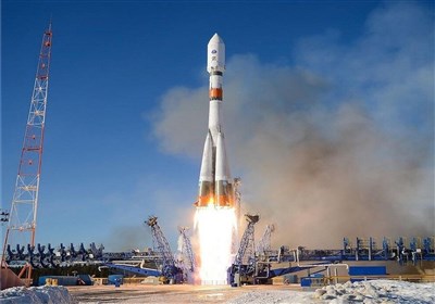
On August 9, 2022, the Iranian satellite Khayyam was launched into orbit by a Russian Soyuz rocket from the Baikonur Cosmodrome in Kazakhstan.
The satellite was sent into an orbit 500 kilometers above the Earth.
The images and data provided by Khayyam, which weighs 600 kilograms, are used in various sectors and sciences, such as agriculture, natural resources, environment, water resources, mines, border control and management of contingencies.
The remote sensing satellite has been controlled and operated fully by the Iranian experts stationed at the space bases of the Ministry of Information and Communications Technology inside Iran.
Shortly after its successful launch, Khayyam has been transmitting telemetry signals.
According to the Iranian Space Agency (ISA), the satellite has been designed to cross over the Iranian sky four times a day and communicate with the ground stations.
The conventional remote-sensing satellites usually need six months to one year to produce the best performance in terms of telemetry, while the process of calibration of Khayyam was conducted only in six months.
Since the cost of the Russian Soyuz satellite carrier is reasonable and the rocket has a high safety factor, many countries with the full technical know-how in the space industry prefer to send their satellites into orbit with the Russian carriers.
Five months after the launch of Khayyam, Iranian Space Agency’s Spokesperson Hossein Dalirian announced in January that Iran was receiving data and images with high accuracy and resolution.
He also noted that the data provided by the homegrown satellite would be gradually shared with various state-run and private sectors to fulfill the country’s needs in agriculture, natural resources, environment, water resources, mines, border control and management of contingencies.
Later on February 7, Iran marked the National Day of Space technology, unveiled the “Nahid-2” and “Tolu’-3” satellites, and publicized the images and data sent by Khayyam.
The Iranian Space Agency later unveiled the images that Khayyam has taken from the Jamkaran Mosque near the city of Qom and the holy shrine of Imam Ali (AS) in Iraq’s Najaf.
On June 19, the images of Al Baqi Cemetery in Saudi Arabia’s Medina, taken by Khayyam from an altitude of 500 km, were published.
The Iranian Space Agency and Iran’s National Cartographic Center on July 3 signed a cooperation agreement in order to make the most of space technologies in geomatics and cartography. The Space Agency has agreed to provide the National Cartographic Center with satellite images and space data under the MoU.
According to the agreement, the two organizations will also cooperate in the compilation and revision of Iran’s national atlases, satellite monitoring of natural disasters, production of applied systems and electronic services, exchange of maps and spatial data, and development of products with added value.
With a 1-meter spatial resolution, Khayyam produces satellite images that would help the country update its maps after around two decades.
Khayyam has been taking satellite images and has covered over 30 percent of the total area of Iran as of June 21.
On July 8, Dalirian said Khayyam satellite has commenced remote sensing activities to monitor and map land use changes.
In collaboration with the Information Technology Organization of Iran (ITO), the ISA is working on legal procedures to prepare and present the initial batch of satellite images to judicial authorities combating land expropriation, he said.
Under an existing memorandum of understanding between the ISA and the ITO, the latter requested more precise data and observation of land surfaces through the satellite to address legal disputes between ordinary citizens and state entities. As data collection and analysis proceed according to the agreement, the two Iranian organizations are exploring legal avenues to achieve their objectives and provide the first set of satellite images to aid in addressing cases of grab and monitoring land use changes.
Dalirian stated, "Khayyam satellite is currently capturing images from various parts of the country as part of efforts to implement the memorandum of understanding. These images will be utilized to address legal challenges faced by ordinary people and state institutions concerning land use changes."
He added, "We are ready to provide necessary data to other Iranian state agencies and assist them in resolving their issues in various fields, including environmental monitoring, water resources, soil erosion, and land subsidence."
Khayyam has marked the initiation of "strategic" aerospace cooperation between Iran and Moscow.
Shortly after the launch, Iran's Space Organization received the first telemetry data transmitted by the Khayyam satellite. It was launched with a velocity of 7.6 kilometers per second and placed into a Low Earth Orbit (LEO) approximately 500 kilometers above the Earth's surface, 480 seconds after liftoff.
The Earth observation satellite is named after the renowned Persian polymath Omar Khayyam, recognized worldwide for his significant contributions to mathematics, astronomy, philosophy, and poetry.
Despite facing sanctions from Western countries in recent years, Iran has made notable advancements in various fields of science and technology.